Smart and efficient 3D scanning
For modelling, inspection, or as-built verification, consistent and accurate data is essential. In practice, however, differences often arise due to varying scan settings and registration methods. With GeoDirect’s 3D solutions, you receive CAD and BIM-ready point clouds right away, without the need for cleanup or discrepancies between field and office.
Home » 3D Solutions
3D scanning is costing your team more time than it should
For construction and infrastructure
A lot of time is lost due to inaccurate or incomplete existing conditions. Scans are sometimes carried out with varying settings, causing models to fail to align properly with dimensions or design. This leads to additional checks, rework, and delays in engineering.
For real estate and renovation
Buildings are often surveyed using different methods, resulting in point clouds that are incomplete, misaligned, or unsuitable for modelling. This requires extensive cleanup, makes clash detection less reliable, and slows down renovation decisions.
3D scanning does not have to be complex
GeoDirect provides scanners, software, and workflows that are preconfigured, tested, and aligned with your CAD, BIM, or GIS environment. This allows you to work immediately with complete point clouds that are correctly registered, without manual conversion or time-consuming cleanup.
Accurate registration without hassle
Scans are automatically and accurately aligned thanks to fixed settings and predefined references. No manual registration, no drift or fragmented datasets, just one coherent and reliable model.
Consistent point clouds for CAD and BIM
Because all workflows are preconfigured, point clouds are always delivered in the correct coordinate system and structure expected by your design or as-built software. This eliminates the need for corrections, conversions, or cleanup.
Reduce dependence on external contractors
Your team can handle both scanning and processing independently using preconfigured workflows and onboarding by our specialists. This removes the need for second surveys, reduces waiting times, and prevents miscommunication between field and engineering
What does this mean for your workflow in practice?
With 3D scanning, project teams gain immediate and accurate insight into existing conditions, volumes, and deviations. The data is ready for use in engineering and planning, enabling faster preparation and reducing risks during execution.
Real-world use case
Work faster and more accurately with high-quality 3D data capture technology
CONTEXT
In complex construction and infrastructure projects, up-to-date and reliable insight into terrain, objects, and dimensions is essential. Traditional surveying methods are time-consuming and often fail to provide sufficient detail for engineering.
WHY 3D?
Thanks to 3D scanning, project teams have immediate access to highly accurate data regarding the current situation, volumes, and any deviations. This information can be seamlessly integrated into engineering and planning, ensuring smoother work preparation and a significant reduction in risks during execution.
SOLUTION
Our 3D technology is delivered with full implementation and hands-on training. Measurement data is sent directly to the office for real-time validation, enabling teams to work faster, more autonomously, and more accurately from day one.
Read in-depth articles and real-world case studies about our projects, workflows, and applications of our geo solutions.

MORE INFORMATION?
Contact our specialist.
Timothy Wattimena
+31(0)6 24 68 43 84
t.wattimena@geodirect.nl
Our Sales Engineers will be happy to show you all the possibilities in a personal demo.


Frequently asked questions
Short answers to the most common questions about our solutions and how they fit into your workflow.
How do you ensure our point clouds are immediately correct in CAD or BIM?
We preconfigure the correct coordinate systems, transformations, and export profiles in advance. As a result, the point cloud is delivered in the correct framework immediately, with no manual corrections required.
Is 3D-scanning eenvoudig op te pakken voor ons team?
Yes. We provide preconfigured workflows, sample projects, and clear guidance during onboarding. Your team learns one consistent way of scanning and processing, ensuring reliable and repeatable results.
Does GeoDirect also support us in choosing the right scanner and workflow for our projects?
Absolutely. Our specialists work with you to review your project types, software stack, and required outputs. Based on this, we recommend the scanner, settings, and workflow that best fit your use case.
Need advice from our Sales Engineer?
Our specialist Timothy will be happy to help you determine which combination of scanners, software, settings, and workflows best fits your projects or surveying processes.
Not just the scanner itself, but the entire setup is reviewed together with you. This includes point clouds, registration methods, data processing, coordinate systems, and integration with CAD or BIM. As a result, everything fits together seamlessly and the information is immediately usable for design, as-built documentation, and execution.
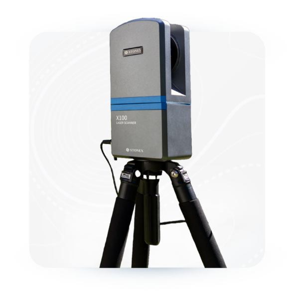
Featured products for 3D scanning
Our 3D scanners and software applications offer maximum versatility, making them the best solution for virtually any 3D application.
Want to stay up to date with the latest developments?
Sign up for our monthly newsletter, packed with innovation and exclusive real-world insights.
Note: By signing up for the newsletter, you agree to our privacy policy. You can unsubscribe at any time.

From the air, from the ground, underwater, and in the soil, we help you capture reality. With innovative measurement solutions and expertise that truly makes technology work in practice.