
Safe and reliable detection of cables and pipelines
For work on cables, pipelines, and underground infrastructure, fast and reliable insight is essential. In practice, however, detection is often carried out using varying settings, methods, and equipment, resulting in data that varies in completeness and accuracy. This makes datasets less useful for design, revision, and transfer.
Home | Detection Solutions
Detection solutions
Uncertain cable and pipeline locations lead to safety and excavation risks.
For grid operators and asset managers
KLIC information and historical records often do not align with the reality in the field. Locations are inaccurate, incomplete, or missing entirely. The discrepancy between the recorded location and the actual location creates risks during excavation work: from material damage and service interruptions to direct safety hazards when a power line or high-pressure pipe is hit.
For infrastructure and contractors
In practice, detection results are often carried out using different tools, settings, and starting points. This creates variation in depth, horizontal positioning, and the interpretation of objects. In combination with deviations from KLIC data, the risk of excavation damage increases. A mislocated cable doesn’t just mean downtime and repair costs; it also puts your employees in direct danger if a live cable or pipe is struck.
At Geodirect, detection does not have to be complicated
We provide detection equipment and workflows that are pre-configured, tested, and aligned with your GIS, CAD, or management system. This ensures you receive consistent results that are immediately usable for design, revision, and transfer, without the need for extra cleaning or corrections.
Fast and consistent detection workflows
With reliable detection and uniform settings during recording, you prevent damage to critical assets. This ensures continuity, safety, and compliance within your management and maintenance processes.
Data that aligns directly with design and revision
With consistent detection workflows, you have reliable information before the first excavation begins, making operations more predictable, reducing risks for your team, and structurally lowering failure costs.
Immediately deployable with specialist support
Your own team can detect and register using pre-set workflows and onboarding from our specialists. This eliminates the need for second surveys and long lead times.
What does this mean for your workflow in practice?
Standardized detection methods provide immediate and accurate insight into the location, depth, and completeness of cables and pipelines. The data integrates directly with engineering, revision, and execution, reducing risks and improving turnaround times.
Use Case
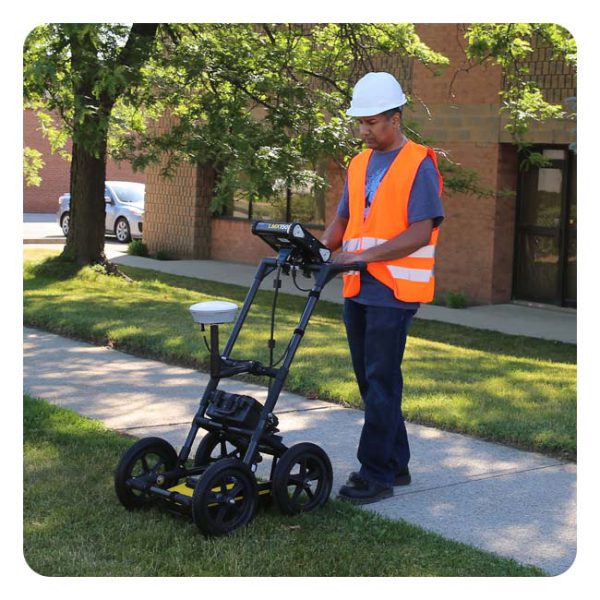
Save days of work with Geodirect's detection solutions
CONTEXT
Modern detection supports the safe installation and replacement of cables and pipelines.
For underground infrastructure, reliable insight into location and depth is essential. Traditional detection often yields variable results due to differences in equipment and workflows.
SOLUTION
With standardized detection techniques, cables, pipelines, and objects are mapped completely and in a controlled manner. This data forms a reliable basis for design, permit applications, and execution.
Our detection solutions are delivered with full implementation and practical training. Results are processed and shared immediately in the correct format, allowing teams to work faster, more autonomously, and more safely from day one.

Our Sales Engineers will be happy to show you all the possibilities in a personal demo.


Frequently asked questions
Short answers to the most common questions about our solutions and how they fit into your workflow.
Do your instruments and software connect to our current GIS or CAD environment?
We coordinate coordinate systems, transformations, and data links with your environment in advance. As a result, measurements are imported correctly immediately, and you have less to correct or convert.
Can our employees work directly with your equipment?
Yes. Everything is delivered ready-to-use with clear settings and sample projects. During onboarding, we explain the workflow so your team can work independently and in a consistent, effective manner.
Does Geodirect also help with setting up fixed measurement and processing profiles?
Certainly. We assist with reference points, coding, and field profiles. This ensures predictable results, less rework, and a more efficient field-to-office workflow.
Need advice from our Sales Engineer?
Our specialist Duncan will be happy to help you determine which combination of detection equipment, settings, workflows, and data delivery best suits your projects or management processes.
Not just the equipment itself, but the entire setup will be reviewed with you. This includes positioning and depth determination, data processing, coordinate systems, integration with CAD or GIS, and transfer to as-built records. This ensures everything connects flawlessly and the information is immediately usable.
Featured products for detection
Locating and protecting underground infrastructure is of crucial importance for many industries. It is therefore vital that your tools guarantee efficiency, safety, and accurate measurements. Radiodetection solutions are specifically designed to meet these requirements.
Want to stay up to date with the latest developments?
Then sign up now for our monthly newsletter, packed with innovation and exclusive real-world insights.
Note: By signing up for the newsletter, you agree to our privacy policy. You can unsubscribe at any time.

From the air, from the ground, underwater, and in the soil, we help you capture reality. With innovative measurement solutions and expertise that truly makes technology work in practice.