
The new standard for efficiency and aerial insights
Drone operations are all about safety, data quality, and a workflow that fits the reality of the field. This requires professional drones, reliable payloads, and software that provides factual and reproducible results rather than interpretations. Geodirect supports organizations and specialists with advanced drone solutions that accelerate processes, from inspection and mapping to incident response and agricultural monitoring. You collect more data in less time and build insights that align directly with design, decision-making, and execution.
Home | Drone Solutions
Drone Solutions
Without an aerial perspective, you are making decisions with only half the information
For contractors, construction, and infrastructure
Project plans are becoming increasingly complex and deadlines tighter. Measuring from the ground provides numbers, but lacks context. Embankments, obstacles, elevation changes, or temporary situations disappear outside the scope of point measurements. This leads to assumptions during design or execution that result in later revisions. Drone data acquisition makes an entire construction site transparent in one go and provides contractors with the certainty needed to build without surprises.
For asset owners and inspection teams
Visual inspections from the ground mean downtime, climbing, equipment rental, or working at heights. Findings are often subjective and not reproducible, forcing teams to return or seek confirmation. Drone inspections bring the detail down to earth without human risk. Assets are captured from multiple angles and compared over time. Trend analysis becomes measurable, maintenance predictable, and downtime is limited to what is strictly necessary.
For public safety and crisis response
In emergency situations, every second counts. Information at eye level is limited and often dangerous to collect. Teams operate with fragmentary clues while the terrain changes dynamically. Drones provide an overview from above, identify heat sources and route errors, and assist in locating persons or fire hazards. Incidents are mapped immediately so that teams act with situational awareness instead of assumptions.
For agriculture and fruit cultivation
Crop care requires insight into patterns that are not observable from the ground. Satellites are slow, low-resolution, and weather-dependent. Field scouting provides detail but lacks scale. Drones bridge this gap with multispectral and RGB data acquisition, allowing you to identify stress zones, soil differences, and variation within plots early on. The result is targeted resource deployment, less waste, and a higher yield per hectare.
With Geodirect, working with drones does not have to be complicated
Geodirect provides drones, sensors, and software that enable your team to independently perform drone data acquisition that is directly applicable to projects. Our Drone Solutions integrate with existing CAD or GIS environments and ensure that orthomosaics, terrain models, and point clouds can be processed without extra manual steps. Mapping, inspections, or monitoring—everything is configured in advance and delivered ready for use. Teams work faster, avoid re-flights, and are less dependent on external parties. No delays or rework, but a workflow where drone, sensor, and software connect logically.
Faster in the field and less post-processing
With drone data acquisition, the entire location is captured in high resolution in a single flight. Orthomosaics, point clouds, and terrain models are generated automatically and align directly with design and analysis. No re-flights, no missing measurement points, and no manual conversions. Through fixed links with CAD and GIS, the transition from raw image data to geometry, classifications, and volume calculations occurs without extra manual labor or intermediate software.
A single source of truth for inspection and decision-making
During drone observation, images and findings are stored immediately in a fixed structure. Assets, objects, or incident areas are thus recorded in a single consistent file, allowing teams to easily compare conditions, damage, and changes. Information is reproducible and uniform, without loose photos, interpretations, or reports that first need to be gathered together.
Operational excellence without external intermediate steps
Your team can independently perform drone observations and process results within pre-configured workflows. This eliminates extra visits, waiting times, and miscommunication between execution, management, and decision-making. Processes remain in-house and the quality of the output is predictable, without dependence on external parties.
Practical Use Case
With aerial data from drones, terrain is fully mapped in a short time without physical access or safety risks. This shortens lead times and improves the quality of inspections.
Case Study
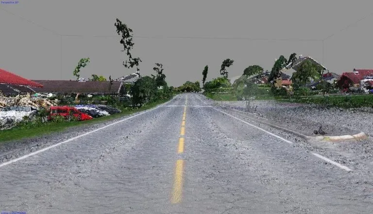
Working faster and safer with drone observation from a VTOL platform.
CONTEXT
Statens Vegvesen needed to survey a mountain route in Norway for maintenance and safety.
The terrain was difficult to access and consisted of steep embankments and narrow sections along a busy route. Traditional inspections were time-consuming and unsafe for personnel along the road.
SOLUTION
The route was captured in a single flight using drone observation.
The entire route, including verges and elevation changes, was documented in hours instead of days.
The images formed a single dataset that was immediately usable for analysis and planning. Extra inspections were not necessary, and the project lead time was significantly reduced.
Drone observation provides fast and safe insight into hard-to-reach areas. An aerial perspective creates a complete overview that significantly accelerates inspections, planning, and decision-making.

MORE INFORMATION?
Contact me.
Timothy Wattimena
+31(0)6 24 68 43 84
t.wattimena@geodirect.nl
Our Sales Engineers will be happy to show you all the possibilities in a personal demo.
Short answers to the most common questions about our solutions and how they fit into your workflow.
What is required for drone mapping?
Geodirect provides a complete package: drone platform, sensors, software for processing and analysis, training programs, and technical support. This allows an organization to become operational immediately without having to integrate individual components themselves.
How does Geodirect assist with implementation and daily use?
In addition to delivery, Geodirect provides instruction, flight training, workflow setup, and remote support. For questions or settings, the support team can assist directly, ensuring projects continue without delay.
Which systems and workflows can be linked to drone data?
The solutions are designed for integration into existing GIS, CAD, and asset management environments. Geodirect advises on which formats, sensors, and software best suit the workflow, so that drone captures are immediately usable within the daily work process.
Need advice from our Sales Engineers?
Our specialist Timothy will be happy to help you determine which combination of scanners, software, settings, and workflows best fits your projects or surveying processes.
Not just the drone itself, but the entire system is reviewed with you. This includes point clouds, registration methods, data processing, coordinate systems, and integration with software applications. This ensures everything connects flawlessly and the information is immediately usable for data acquisition and execution.
Featured products for Drone Mapping
Drone solutions make it possible to capture terrain, infrastructure, and hard-to-reach locations quickly and safely from the air. Equipped with high-quality cameras or LiDAR sensors, drones deliver accurate orthophotos, 3D models, and terrain measurements without physical access to the area. This creates a complete and reliable overview in a short time that is immediately applicable for inspection, planning, and documentation.
Want to stay up to date with the latest developments?
Then sign up now for our monthly newsletter, packed with innovation and exclusive real-world insights.
Note: By signing up for the newsletter, you agree to our privacy policy. You can unsubscribe at any time.

From the air, from the ground, underwater, and in the soil, we help you capture reality. With innovative measurement solutions and expertise that truly makes technology work in practice.