The world beneath the water surface remains hidden without the right technology
Waterways, ports, and quay zones are constantly changing. Sedimentation, erosion, obstacles, and depth variation are crucial for management, maintenance, and safety. Traditional methods only see what is visible above water. The waterbed itself remains an unknown variable. Hydrography Solutions from Geodirect provide insight into this reality. With bathymetric workflows, you can map bottom profiles completely and reproducibly. No dangerous measurement days, no guesswork, but data you can use to make decisions.
Home » Hydrography Solutions
Hydrography Solutions
Traditional measurements leave too much to chance
Handheld depth sounders, sounding poles, or point measurements from the shore only provide a fragment of the actual situation. Depth becomes a guess between measurement points. Steep banks, currents, or poorly accessible zones increase the chance of errors. The result is more boat trips, dangerous situations, and datasets that do not align with design or management.
For water management and dredging projects
Sedimentation is dynamic and shifts with seasons, flow velocity, and precipitation. Working with old maps or estimates leads to under- or over-dredging, delays, and unnecessary costs. Bathymetry records volumes and depth differences directly. Water managers plan targeted maintenance moments and see exactly where silting occurs. No additional measurements, but action based on current geometry.
For civil engineering and hydraulic structures
Underwater structures determine the lifespan of bridges, quays, locks, and foundations. Small deviations underwater have major consequences above water. Bathymetry systematically visualizes erosion, hollows, and slope shapes. Engineers receive a substantiated basis for inspection, stability analysis, and maintenance, without divers or vessel platforms.
For ports, recreation, and safety
Shallow areas, obstacles, and changing slopes pose a risk to shipping and recreational users. Periodic bathymetry brings these changes to light early. This way, hazards become visible before incidents occur, allowing you to take measures with policy.
Bathymetry records the entire bottom in a single session
Bathymetric acquisition shows what lies hidden beneath the water surface. Instead of isolated points, a continuous profile of the waterbed is created, including shape, slopes, and sediment zones. Where visual inspections end, bathymetry makes patterns visible. This provides decision-making information for design, dredging planning, asset management, and safety. One sailing session, one dataset, one reality.
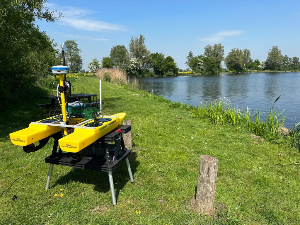
Autonomous insight without risks using USVs
Measurements on inland waters or in ports are risky for personnel due to vessel traffic, weather conditions, and limited maneuvering space, creating an unsafe working environment. Unmanned Surface Vehicle systems (USVs) eliminate these risks. Your team performs bathymetry independently within established workflows, and extra visits, waiting times, and interpretation differences disappear. This keeps process, quality, and planning in your own hands without dependence on external parties.
Sonar shows what the water surface hides
Active sonar sends out sound pulses and reads back echoes. This provides depth, shape, and texture of the bottom. Not as isolated points, but as recognizable profiles and structures. Whether it concerns profile measurements, soft sediment layers, or object detection, sonar forms the basis for professional bathymetry. Where visual sight stops, sonar offers the necessary precision for design, management, and analysis.
From depth measurements to usable bottom models
Bathymetry does not deliver a spreadsheet, but a digital representation of the bottom. The acquisition is translated into DTMs in which only the waterbed is visible. Slope angles, unstable banks, and sediment accumulation become clear. Bottom classification distinguishes between sand, silt, hard ground, or vegetation. Design and management decisions are substantiated instead of guessed.
What does this mean for your workflow in practice?
Bathymetry becomes a standard part of your process. Sailing routes, parameters, and processing are pre-defined so that datasets are reproducible in time and location. Depth profiles, volumes, and bottom structures connect directly to CAD and GIS. You work faster, prevent extra boat trips, and base decisions on consistent data.
Case Study
Inspection of underwater structures at bridge pillars

CONTEXT
Autonomous execution without rework
During the inspection of bridge foundations, Rijkswaterstaat needed to gain insight into erosion and sedimentation around several pillars. The locations were poorly accessible with a manned boat, and the use of divers involved safety risks. Traditional random point measurements provided an insufficient picture of the bottom shape, necessitating additional field visits.
SOLUTION
A USV was deployed to follow controlled sailing routes under the bridge and fully record the area depth with sonar.
The sailing session yielded a continuous bottom profile, including scour, soft silt layers, and zones of sediment buildup. The information was captured in a single dataset, without vessel platforms or diving work.
No separate files, but one consistent basis for decisions throughout the project.
RESULT
The inspection team could immediately determine which pillars were at risk and where maintenance was required.
No extra measurements were needed, and personnel safety remained guaranteed. The lead time of the investigation was significantly shortened, and decision-making was based on objective data instead of interpretation.
Read more about how Rijkswaterstaat uses USV technology for safe and complete underwater inspections?

Our Sales Engineers would be happy to show you all the possibilities in a personal demo
Short answers to the most common questions about our solutions and how they fit into your workflow.
Do your instruments and software connect to our current GIS or CAD environment?
We coordinate coordinate systems, transformations, and data links with your environment in advance. As a result, measurements are imported correctly immediately, and you have less to correct or convert.
Can our employees work directly with your equipment?
Yes. Everything is delivered ready-to-use with clear settings and example projects. During onboarding, we explain the workflow so that your team can work independently and in a consistent, effective manner.
Does Geodirect also help with setting up fixed measurement and processing profiles?
Certainly. Bathymetric datasets are stored in a fixed structure that aligns with your design and management environment. Profiles, sections, and 3D models can be compared or analyzed without conversions. No separate files, but one consistent basis for decisions throughout the project.
Need advice from our Sales Engineers?
Our specialist Duncan will be happy to help you determine which combination of hydrography equipment, settings, workflows, and data delivery best suits your projects or management processes.
Not just the equipment itself, but the entire setup will be reviewed with you. This includes positioning and depth determination, data processing, coordinate systems, integration with CAD or GIS, and transfer to as-built records. This ensures everything connects flawlessly and the information is immediately usable.
Featured products for hydrography
Hydrographic and bathymetric measurements in coastal and inland waters can be risky and inefficient with traditional manned vessels. Modular Unmanned Surface Vehicle systems (USVs) offer a safe and cost-effective alternative to traditional manned vessels. Equipped with single-beam or multi-beam sonar, they accurately record the bottom shape, even in shallow or hard-to-reach waters where manned platforms cannot operate.
Want to stay up to date with the latest developments?
Then sign up now for our monthly newsletter, packed with innovation and exclusive real-world insights.
Note: By signing up for the newsletter, you agree to our privacy policy. You can unsubscribe at any time.

From the air, from the ground, underwater, and in the soil, we help you capture reality. With innovative measurement solutions and expertise that truly makes technology work in practice.