Stonex Reconstructor training
From scan data to accurate 3D models
Home » Stonex Reconstructor training
Stonex Reconstructor training
From scan data to accurate 3D models
The Stonex Reconstructor training is designed for professionals who want to process laser scan data and point clouds into accurate 3D models.
During this training, you will learn how to correctly import, edit, and merge scan data into complete digital models. You will discover how to fit scans into the correct coordinate system, generate 3D models, and export them for further analysis and visualization.
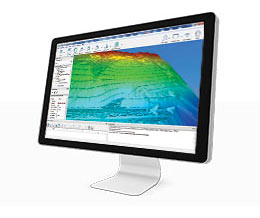
With Stonex Reconstructor, you convert raw scan data into high-quality, georeferenced 3D reconstructions. After completing this training, you will have mastered the full workflow from scan to model.
From scan data to accurate 3D models
The Stonex Reconstructor training is designed for professionals who want to process laser scan data and point clouds into accurate 3D models.
During this training, you will learn how to correctly import, edit, and merge scan data into complete digital models. You will discover how to fit scans into the correct coordinate system, generate 3D models, and export them for further analysis and visualization.
With Stonex Reconstructor, you convert raw scan data into high-quality, georeferenced 3D reconstructions. After completing this training, you will have mastered the full workflow from scan to model.
What will you learn?
- Becoming familiar with the Stonex Reconstructor interface: Navigating and working efficiently with the software.
- Importing and processing scan data: Importing raw scans and optimizing point clouds.
- Referencing scans to each other (LineUp): Automatic and manual alignment of multiple scans, including target-less registration and bundle adjustment.
- Fitting scan data into the correct coordinate system: Georeferencing with Ground Control Points (GCPs) and known coordinates.
- Creating 3D models (Mesh & Shapes): Converting scan data into 3D surfaces and generating mesh models.
- Classifying and editing point clouds (Cloud Tools): Filtering, manual classification, and color management within the dataset.
- Generating orthophotos (Orthophoto): Creating standard and X-ray orthophotos based on point clouds and meshes.
- Exporting CAD and BIM data (CAD Output): Converting isolines, cross-sections, and elevation data to CAD and GIS formats.
- Final assessment and certificate: confirmation of your knowledge and free support after completion.
Applied learning
True expertise comes from doing. In this training, you will work with practical assignments and realistic project cases, so you can immediately apply Stonex Reconstructor in your work environment.
The training concludes with a final test. Upon successful completion, you will receive a certificate and gain access to free support from our support department.
Training details
- Duration: 1 day, from 09:00 to 17:00.
- Group size: maximum of 8 participants, ensuring optimal personal guidance.
- Locations: Mijdrecht, the Netherlands; Turnhout, Belgium; or on-site at your location.
- Investment: €550 per person, including course materials, certificate, lunch, and refreshments.
Register easily for the Stonex Cube-a GNSS training via the registration form on this page. Choose a date and location, enter your details, and submit your registration.
Have you already purchased this training with your Stonex RTK GNSS surveying equipment? If so, enter your order number in the comments field. After registering, you will receive an email confirmation with all the details about your participation.
Do you have any questions or would you like personal advice?
Call +31 (0)297 769 101 or contact us via the contact page.
Register for this training?
Fill in the form below and we will contact you regarding available dates.
Looking for a different training?
Bekijk het volledige overzicht op onze trainingspagina.