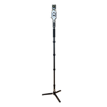
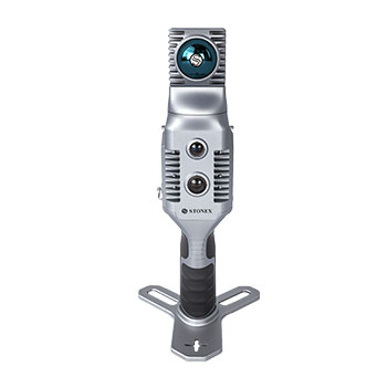
Stonex X70GO for fast 3D scanning of buildings, infrastructure, and tunnels
The Stonex X70GO combines a 360° rotating scanner head with advanced SLAM technology for rapid capture of complex environments. Thanks to real-time visualization, hybrid scanning capabilities, and a range of up to 70 m, the X70GO is suitable for surveying, infrastructure, building documentation, and inspection work.
Rotating scanner head for maximum coverage
The 360° rotating scanner mechanism ensures optimal coverage of the environment and delivers accurate point clouds, even in spaces with little structure. The integrated camera supports the SLAM algorithm and increases positioning reliability during scanning.
X-Whizz hybrid scanning
Combines mobile SLAM scans with static scans for extra detail at critical locations.
Real-time visualization
Check the point cloud directly during scanning via GOapp.
Automatic control point measurement
Reference points are automatically included for efficient georeferencing.
Flexible use for diverse projects
From tunnels and technical installations to heritage buildings and infrastructure projects. The X70GO delivers quickly usable point clouds that can be processed directly within Cube-3d, PointCab, and other software platforms.
200,000 points per second
High scan speed for efficient data collection.
Range up to 70 m
Suitable for both small spaces and larger buildings.
360° scanner head
Optimal coverage of the environment during every scan.
Multiple mounting options
Can be used as a handheld, on a monopod, backpack, or shoulder bracket.
From the air, from the ground, underwater, and in the soil, we help you capture reality. With innovative measurement solutions and expertise that truly makes technology work in practice.
Whether it involves scanning, measuring, detecting, or positioning, you will find a suitable solution for every project with our wide range of geospatial solutions.
Whether it involves scanning, measuring, detecting, or positioning, you will find a suitable solution for every project with our wide range of geospatial solutions.
Whether it involves scanning, measuring, detecting, or positioning, you will find a suitable solution for every project with our wide range of geospatial solutions.
Whether it involves scanning, measuring, detecting, or positioning, you will find a suitable solution for every project with our wide range of geospatial solutions.
Whether it involves scanning, measuring, detecting, or positioning, you will find a suitable solution for every project with our wide range of geospatial solutions.
Whether it involves scanning, measuring, detecting, or positioning, you will find a suitable solution for every project with our wide range of geospatial solutions.
At Geodirect, we value high-quality implementation for all our hardware and software solutions. That is why you can also rely on us for training, support, and maintenance.
At Geodirect, we value high-quality implementation for all our hardware and software solutions. That is why you can also rely on us for training, support, and maintenance.
Geodirect B.V. Vermogenweg 107 3641 SR Mijdrecht The Netherlands
Chamber of Commerce number 51485532 VAT number NL850045538B01 IBAN NL43RABO0157787338 BIC RABONL2U
Whether it involves scanning, measuring, detecting, or positioning, you will find a suitable solution for every project with our wide range of geospatial solutions.
Whether it involves scanning, measuring, detecting, or positioning, you will find a suitable solution for every project with our wide range of geospatial solutions.
Whether it involves scanning, measuring, detecting, or positioning, you will find a suitable solution for every project with our wide range of geospatial solutions.
Whether it involves scanning, measuring, detecting, or positioning, you will find a suitable solution for every project with our wide range of geospatial solutions.
Whether it involves scanning, measuring, detecting, or positioning, you will find a suitable solution for every project with our wide range of geospatial solutions.
Whether it involves scanning, measuring, detecting, or positioning, you will find a suitable solution for every project with our wide range of geospatial solutions.
Whether it involves scanning, measuring, detecting, or positioning, you will find a suitable solution for every project with our wide range of geospatial solutions.
Whether it involves scanning, measuring, detecting, or positioning, you will find a suitable solution for every project with our wide range of geospatial solutions.
Whether it involves scanning, measuring, detecting, or positioning, you will find a suitable solution for every project with our wide range of geospatial solutions.
At Geodirect, we value high-quality implementation for all our hardware and software solutions. That is why you can also rely on us for training, support, and maintenance.
At Geodirect, we value high-quality implementation for all our hardware and software solutions. That is why you can also rely on us for training, support, and maintenance.
Geodirect B.V. Vermogenweg 107 3641 SR Mijdrecht The Netherlands
Chamber of Commerce number 51485532 VAT number NL850045538B01 IBAN NL43RABO0157787338 BIC RABONL2U
Whether it involves scanning, measuring, detecting, or positioning, you will find a suitable solution for every project with our wide range of geospatial solutions.