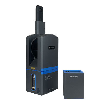
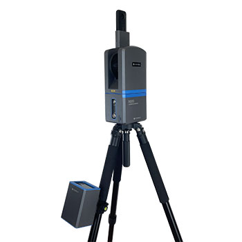
Stonex X100 for fast and accurate terrestrial 3D scanning
The Stonex X100 is a compact terrestrial laser scanner that combines high-quality point clouds with a simple workflow. With a full 360° scan in just 45 seconds, a range of up to 120 meters, and a weight of only 3.2 kilograms, the X100 is an efficient solution for topographic surveys, building documentation, real estate inventories, and infrastructure projects.
Full 360° scan in just 45 seconds
The X100 captures a full 360° x 268° scan range at the touch of a button. This allows projects to be completed faster than with traditional measurement methods. Thanks to the high scan speed of 320,000 points per second, a detailed point cloud is instantly created for further processing.
Scan in 45 seconds
Full 360° scan for fast data collection in the field.
HDR panoramic camera
Realistic colorized point clouds, even in varying lighting conditions.
Self-calibrating system
Automatic compensation and control of horizontal alignment.
Simple workflow from scan to final result
The scanner is operated wirelessly via the X100app, allowing the recording quality to be checked immediately. After completion, the data is processed within Cube-3d, Stonex Reconstructor, or other point cloud software for further analysis, modeling, and documentation.
320,000 points per second
High scan speed for efficient project execution.
Range up to 120 meters
Suitable for buildings, halls, facades, and outdoor areas.
Accuracy 6 mm at 10 meters
Professional measurement quality for various applications.
From the air, from the ground, underwater, and in the soil, we help you capture reality. With innovative measurement solutions and expertise that truly makes technology work in practice.
Whether it involves scanning, measuring, detecting, or positioning, you will find a suitable solution for every project with our wide range of geospatial solutions.
Whether it involves scanning, measuring, detecting, or positioning, you will find a suitable solution for every project with our wide range of geospatial solutions.
Whether it involves scanning, measuring, detecting, or positioning, you will find a suitable solution for every project with our wide range of geospatial solutions.
Whether it involves scanning, measuring, detecting, or positioning, you will find a suitable solution for every project with our wide range of geospatial solutions.
Whether it involves scanning, measuring, detecting, or positioning, you will find a suitable solution for every project with our wide range of geospatial solutions.
Whether it involves scanning, measuring, detecting, or positioning, you will find a suitable solution for every project with our wide range of geospatial solutions.
At Geodirect, we value high-quality implementation for all our hardware and software solutions. That is why you can also rely on us for training, support, and maintenance.
At Geodirect, we value high-quality implementation for all our hardware and software solutions. That is why you can also rely on us for training, support, and maintenance.
Geodirect B.V. Vermogenweg 107 3641 SR Mijdrecht The Netherlands
Chamber of Commerce number 51485532 VAT number NL850045538B01 IBAN NL43RABO0157787338 BIC RABONL2U
Whether it involves scanning, measuring, detecting, or positioning, you will find a suitable solution for every project with our wide range of geospatial solutions.
Whether it involves scanning, measuring, detecting, or positioning, you will find a suitable solution for every project with our wide range of geospatial solutions.
Whether it involves scanning, measuring, detecting, or positioning, you will find a suitable solution for every project with our wide range of geospatial solutions.
Whether it involves scanning, measuring, detecting, or positioning, you will find a suitable solution for every project with our wide range of geospatial solutions.
Whether it involves scanning, measuring, detecting, or positioning, you will find a suitable solution for every project with our wide range of geospatial solutions.
Whether it involves scanning, measuring, detecting, or positioning, you will find a suitable solution for every project with our wide range of geospatial solutions.
Whether it involves scanning, measuring, detecting, or positioning, you will find a suitable solution for every project with our wide range of geospatial solutions.
Whether it involves scanning, measuring, detecting, or positioning, you will find a suitable solution for every project with our wide range of geospatial solutions.
Whether it involves scanning, measuring, detecting, or positioning, you will find a suitable solution for every project with our wide range of geospatial solutions.
At Geodirect, we value high-quality implementation for all our hardware and software solutions. That is why you can also rely on us for training, support, and maintenance.
At Geodirect, we value high-quality implementation for all our hardware and software solutions. That is why you can also rely on us for training, support, and maintenance.
Geodirect B.V. Vermogenweg 107 3641 SR Mijdrecht The Netherlands
Chamber of Commerce number 51485532 VAT number NL850045538B01 IBAN NL43RABO0157787338 BIC RABONL2U
Whether it involves scanning, measuring, detecting, or positioning, you will find a suitable solution for every project with our wide range of geospatial solutions.