STX-DIG 1D for accurate digging with every excavator
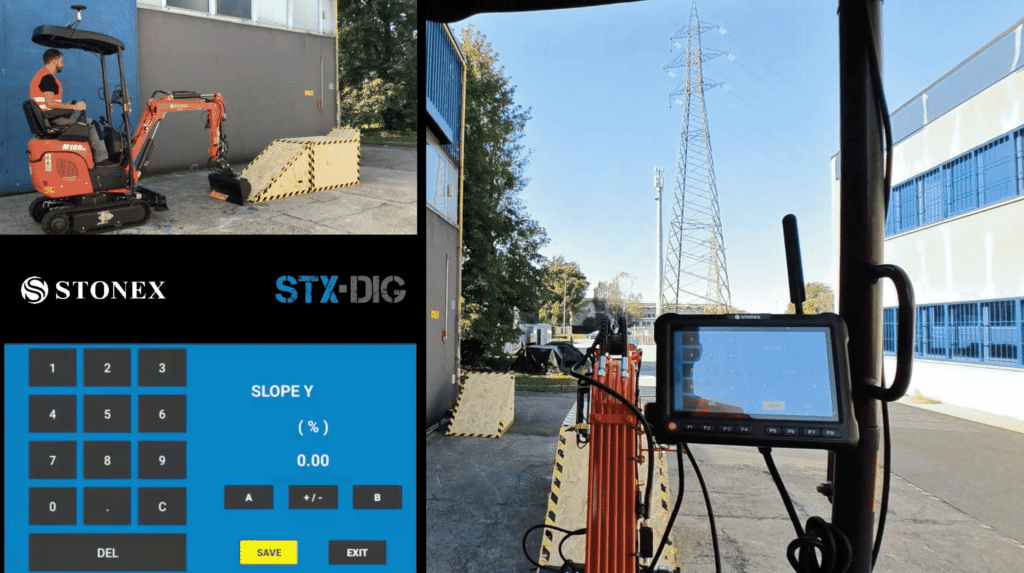
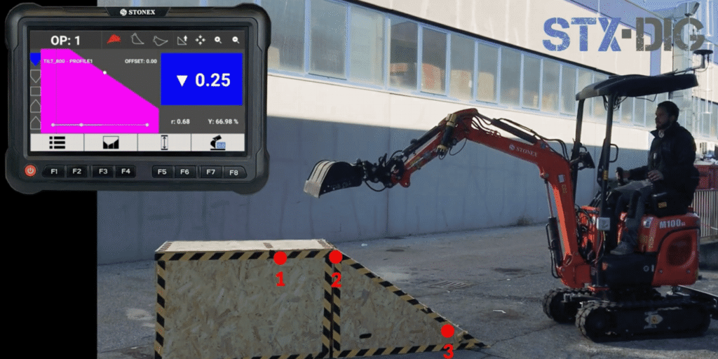
STX-DIG 1D is the entry-level system within the Stonex Machine Control platform for excavators. The system provides the operator with real-time insight into the bucket position in side view and enables accurate digging without constant check measurements. Ideal for earthmoving professionals who want to work more efficiently while increasing the accuracy of their work.
Always insight into the bucket position
Sensors on the frame, boom, stick, and bucket continuously measure the position of the excavator arm. The operator sees the current bucket position relative to the set working height directly on the Apollo tablet. This allows trenches, foundations, and slopes to be created more accurately, even when the bucket is out of sight or working underwater.
Quick installation
Installation by a certified technician typically takes only a few hours, making the machine operational quickly.
Affordable entry into machine control
A cost-effective solution for more accurate digging with less rework and higher productivity.
Fully expandable
Easily upgradeable to 2D or 3D machine control while retaining existing hardware.
Suitable for almost any excavator
STX-DIG 1D can be applied to almost any brand and type of excavator, from mini-excavators to heavy earthmoving machines. The system consists of sensors, cabling, and the Apollo tablet. Optionally, a laser sensor can be added for automatic height transfer and support for work without GNSS corrections.
Height reference
Height transfer via a reference point or optional rotating laser.
Sensor set
Sensors on the frame, boom, stick, and bucket for continuous positioning.
Apollo tablet
Clear STX-MC software specifically developed for in-cab use.
Expandable platform
Prepared for expansion to 2D and 3D machine control.
From the air, from the ground, underwater, and in the soil, we help you capture reality. With innovative measurement solutions and expertise that truly makes technology work in practice.
Whether it involves scanning, measuring, detecting, or positioning, you will find a suitable solution for every project with our wide range of geospatial solutions.
Whether it involves scanning, measuring, detecting, or positioning, you will find a suitable solution for every project with our wide range of geospatial solutions.
Whether it involves scanning, measuring, detecting, or positioning, you will find a suitable solution for every project with our wide range of geospatial solutions.
Whether it involves scanning, measuring, detecting, or positioning, you will find a suitable solution for every project with our wide range of geospatial solutions.
Whether it involves scanning, measuring, detecting, or positioning, you will find a suitable solution for every project with our wide range of geospatial solutions.
Whether it involves scanning, measuring, detecting, or positioning, you will find a suitable solution for every project with our wide range of geospatial solutions.
At Geodirect, we value high-quality implementation for all our hardware and software solutions. That is why you can also rely on us for training, support, and maintenance.
At Geodirect, we value high-quality implementation for all our hardware and software solutions. That is why you can also rely on us for training, support, and maintenance.
Geodirect B.V. Vermogenweg 107 3641 SR Mijdrecht The Netherlands
Chamber of Commerce number 51485532 VAT number NL850045538B01 IBAN NL43RABO0157787338 BIC RABONL2U
Whether it involves scanning, measuring, detecting, or positioning, you will find a suitable solution for every project with our wide range of geospatial solutions.
Whether it involves scanning, measuring, detecting, or positioning, you will find a suitable solution for every project with our wide range of geospatial solutions.
Whether it involves scanning, measuring, detecting, or positioning, you will find a suitable solution for every project with our wide range of geospatial solutions.
Whether it involves scanning, measuring, detecting, or positioning, you will find a suitable solution for every project with our wide range of geospatial solutions.
Whether it involves scanning, measuring, detecting, or positioning, you will find a suitable solution for every project with our wide range of geospatial solutions.
Whether it involves scanning, measuring, detecting, or positioning, you will find a suitable solution for every project with our wide range of geospatial solutions.
Whether it involves scanning, measuring, detecting, or positioning, you will find a suitable solution for every project with our wide range of geospatial solutions.
Whether it involves scanning, measuring, detecting, or positioning, you will find a suitable solution for every project with our wide range of geospatial solutions.
Whether it involves scanning, measuring, detecting, or positioning, you will find a suitable solution for every project with our wide range of geospatial solutions.
At Geodirect, we value high-quality implementation for all our hardware and software solutions. That is why you can also rely on us for training, support, and maintenance.
At Geodirect, we value high-quality implementation for all our hardware and software solutions. That is why you can also rely on us for training, support, and maintenance.
Geodirect B.V. Vermogenweg 107 3641 SR Mijdrecht The Netherlands
Chamber of Commerce number 51485532 VAT number NL850045538B01 IBAN NL43RABO0157787338 BIC RABONL2U
Whether it involves scanning, measuring, detecting, or positioning, you will find a suitable solution for every project with our wide range of geospatial solutions.