STX-DIG 3D Pro for full 3D machine control of excavators
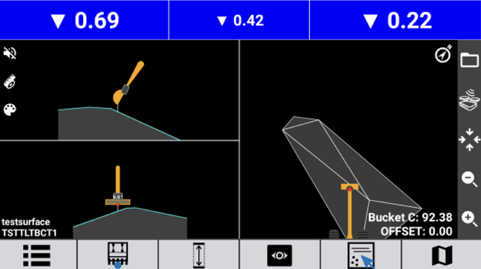
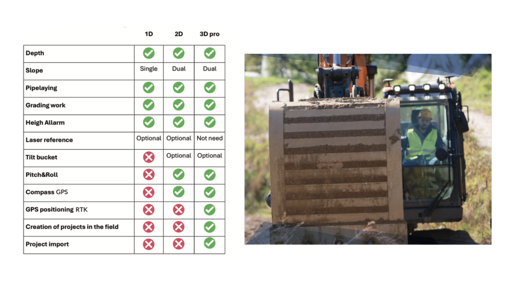
STX-DIG 3D Pro is the most comprehensive configuration within the Stonex Machine Control platform for excavators. The system combines angle sensors on the excavator arm with the SMC-TWO GNSS RTK receiver for full bucket positioning on the job site. This allows you to work directly with digital design models and move the machine freely across the terrain without manual height transfers or reorientation.
Move freely across the job site with GNSS RTK
The SMC-TWO dual-antenna GNSS RTK receiver continuously determines the machine’s position and heading. Corrections are received via NTRIP or UHF radio, ensuring accurate work even in locations with limited mobile coverage. Projects can be imported directly from DXF and XML files or created directly on the Apollo tablet.
NTRIP and UHF corrections
Supports both mobile RTK corrections and UHF radio for maximum flexibility on every job site.
STX-Cloud project management
Share projects, calibrations, and configurations centrally with multiple machines and users.
Tiltrotator integration
Support for factory-fitted tiltrotators via CAN-bus for extended machine functionality.
Project management, cloud integration, and remote support
Via STX-Cloud, projects can be managed centrally and shared instantly with machines in the field. Project changes are immediately available on the Apollo tablet. Additionally, remote support enables off-site assistance, minimizing downtime.
SMC-TWO GNSS RTK receiver
Dual GNSS antennas for precise positioning and heading detection.
DXF and XML projects
Import digital design files directly from the office to the machine.
Tilt bucket and tiltrotator
Support for tilt bucket sensors and tiltrotators for maximum flexibility.
Upgradable
Existing STX-DIG 1D and 2D systems can be easily expanded to 3D Pro.
From the air, from the ground, underwater, and in the soil, we help you capture reality. With innovative measurement solutions and expertise that truly makes technology work in practice.
Whether it involves scanning, measuring, detecting, or positioning, you will find a suitable solution for every project with our wide range of geospatial solutions.
Whether it involves scanning, measuring, detecting, or positioning, you will find a suitable solution for every project with our wide range of geospatial solutions.
Whether it involves scanning, measuring, detecting, or positioning, you will find a suitable solution for every project with our wide range of geospatial solutions.
Whether it involves scanning, measuring, detecting, or positioning, you will find a suitable solution for every project with our wide range of geospatial solutions.
Whether it involves scanning, measuring, detecting, or positioning, you will find a suitable solution for every project with our wide range of geospatial solutions.
Whether it involves scanning, measuring, detecting, or positioning, you will find a suitable solution for every project with our wide range of geospatial solutions.
At Geodirect, we value high-quality implementation for all our hardware and software solutions. That is why you can also rely on us for training, support, and maintenance.
At Geodirect, we value high-quality implementation for all our hardware and software solutions. That is why you can also rely on us for training, support, and maintenance.
Geodirect B.V. Vermogenweg 107 3641 SR Mijdrecht The Netherlands
Chamber of Commerce number 51485532 VAT number NL850045538B01 IBAN NL43RABO0157787338 BIC RABONL2U
Whether it involves scanning, measuring, detecting, or positioning, you will find a suitable solution for every project with our wide range of geospatial solutions.
Whether it involves scanning, measuring, detecting, or positioning, you will find a suitable solution for every project with our wide range of geospatial solutions.
Whether it involves scanning, measuring, detecting, or positioning, you will find a suitable solution for every project with our wide range of geospatial solutions.
Whether it involves scanning, measuring, detecting, or positioning, you will find a suitable solution for every project with our wide range of geospatial solutions.
Whether it involves scanning, measuring, detecting, or positioning, you will find a suitable solution for every project with our wide range of geospatial solutions.
Whether it involves scanning, measuring, detecting, or positioning, you will find a suitable solution for every project with our wide range of geospatial solutions.
Whether it involves scanning, measuring, detecting, or positioning, you will find a suitable solution for every project with our wide range of geospatial solutions.
Whether it involves scanning, measuring, detecting, or positioning, you will find a suitable solution for every project with our wide range of geospatial solutions.
Whether it involves scanning, measuring, detecting, or positioning, you will find a suitable solution for every project with our wide range of geospatial solutions.
At Geodirect, we value high-quality implementation for all our hardware and software solutions. That is why you can also rely on us for training, support, and maintenance.
At Geodirect, we value high-quality implementation for all our hardware and software solutions. That is why you can also rely on us for training, support, and maintenance.
Geodirect B.V. Vermogenweg 107 3641 SR Mijdrecht The Netherlands
Chamber of Commerce number 51485532 VAT number NL850045538B01 IBAN NL43RABO0157787338 BIC RABONL2U
Whether it involves scanning, measuring, detecting, or positioning, you will find a suitable solution for every project with our wide range of geospatial solutions.